Lake St. Clair looks easy until you are the one behind the wheel trying to read shallow water, dodge no wake zones, avoid trouble spots, and still find your way to the right destination.
That is why this page exists.
Whether you are heading to Muscamoot Bay, chasing calmer water, planning a fishing trip, or just trying to avoid rookie mistakes, the right map changes everything. A good day on the lake usually starts before the boat ever leaves the trailer. Know the depth. Know the channels. Know the hazards. Know where the fish are likely holding.
Use the sections below to get your bearings before you launch.
Lake Depth Map
If you want the fastest way to understand Lake St. Clair, start with the depth map.
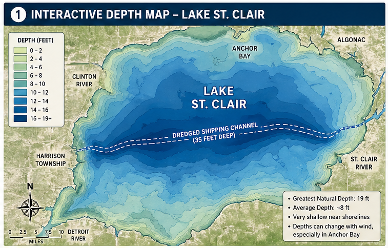
This is the map that helps you see the big picture fast. You can get a feel for shallow water, deeper cuts, and how the lake really lays out instead of guessing by sight alone. That matters on Lake St. Clair because this is a broad, shallow lake with a flat bottom in many areas, and the deeper commercial channel cuts across it in a way many first timers underestimate.
Before you throttle up, spend a few minutes here. It is one of the easiest ways to understand where you can move confidently and where you should slow down and pay closer attention.
Classic Boater Navigation Chart
Some maps are made to look pretty. Others are made to keep you out of trouble.
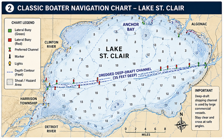
This section is for the old school chart style serious boaters still trust. A true navigation chart gives you the kind of detail that matters on the water, including marked channels, shoals, depth contours, and the bigger picture of how commercial and recreational traffic share the lake. Lake St. Clair’s dredged deep-draft channel is one of the most important features on the water, and it is a major reason a proper navigation chart still matters.
If you are the kind of person who likes to know what is ahead before you get there, this is your map.
No Wake Zones, Slow Areas & Trouble Spots
A lot of frustration on Lake St. Clair comes from things that have nothing to do with weather.
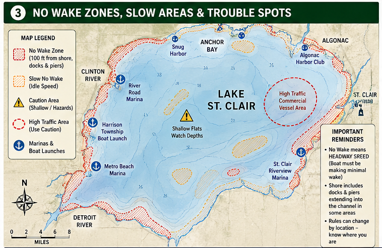
People get ticketed, boxed in, or caught off guard because they do not realize where the no wake zones are, how far some docks extend into the channel, or how quickly the rules can change depending on where they are running. Updated Lake St. Clair no wake zone maps are available for different boat sizes, and local guidance specifically notes that shore includes docks and piers extending into the channel in some places.
This section is here to help you avoid the kind of mistakes that turn a fun day into an expensive one.
Fishing Map & Fish Zones
Lake St. Clair is not just a boating destination. It is one of the most talked about freshwater fisheries in the region.
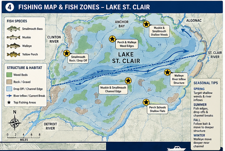
If you are fishing, a general lake map is not enough. You want something that helps you think like an angler. That means structure, access, marked fishing areas, seasonal movement, and which species are most likely to be where. Lake St. Clair is widely recognized for smallmouth bass, muskie, walleye, and yellow perch, and several dedicated fishing map providers highlight those same species as the headline draw for the lake.
A strong fishing map does more than show water. It helps you fish with a reason.
Why These Maps Matter
Lake St. Clair rewards preparation.
The lake has a greatest natural depth of 19 feet, but much of it feels broad, shallow, and deceptively open, especially around bays and flats. Water levels can also shift with wind, with the effect especially pronounced in Anchor Bay. That is why boaters, anglers, and first timers all benefit from looking at the lake through more than one lens. One map shows the depth. Another shows the channels. Another shows the rules. Another helps you chase fish instead of guesses.
The more you understand before you leave the dock, the more freedom you have once you are out there.